Image
A picture may be worth a thousand words, but how many lives can it save? New research is using hyper-detailed satellite imaging and combining it with world agricultural data to predict food scarcity in Africa.
While many NGOs rely on survey-based responses to predict food security or on-the-ground reporting of supply chain failures and economic trends, one team of researchers at the University of Virginia’s School of Data Science is turning to images. They’re not relying on just any images, but powerfully pixelated images taken by remote NASA satellites.
Jade Preston, a doctoral student in data science and an active-duty operations research analyst with the U.S. Air Force, is using remote sensing and hyperspectral image classification to get the big picture around food insecurity. She’s working with faculty advisor Bill Basener, an expert in remote imaging and data science.
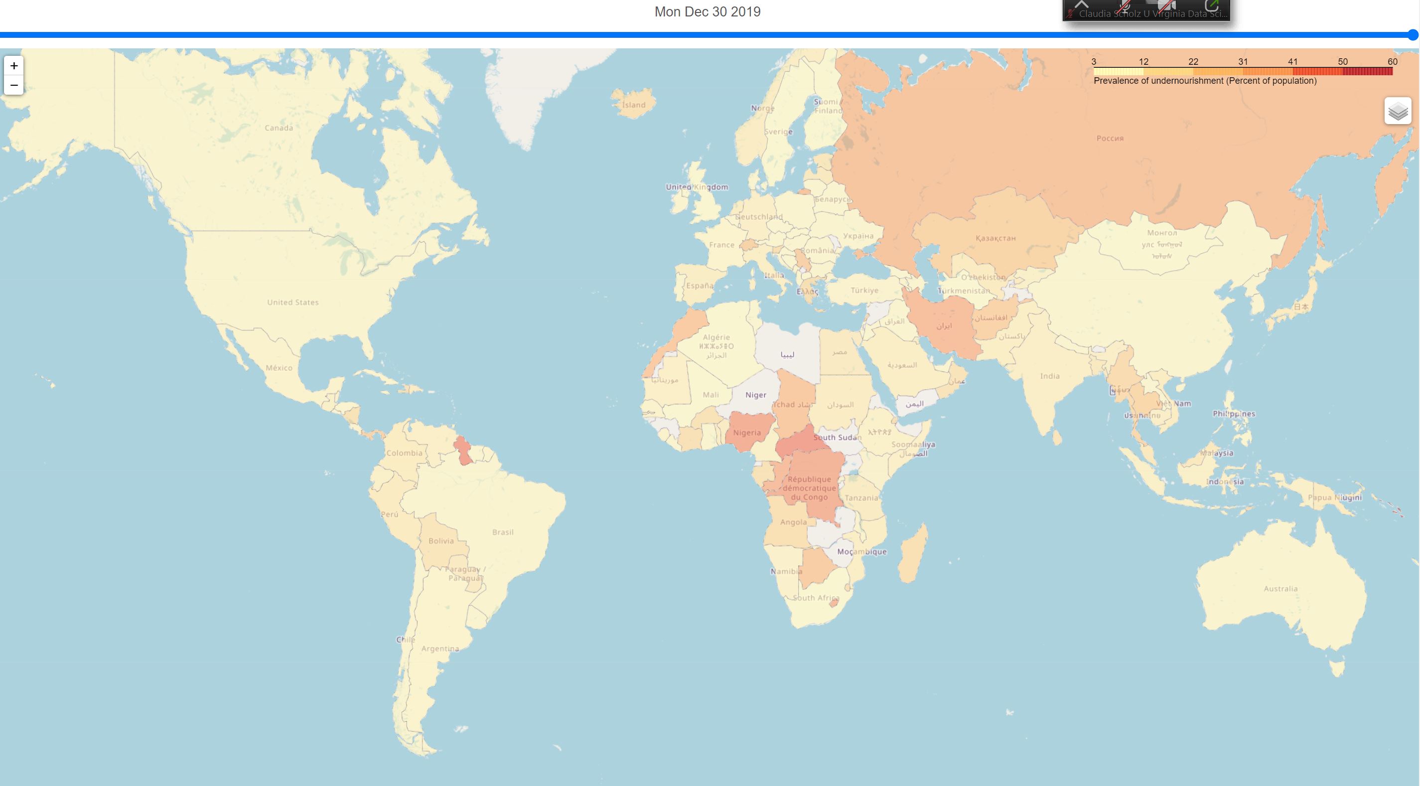
Food insecurity has been a top issue in Africa for decades and is a present threat to more than 20% of the continental population. According to the U.N. Food and Agriculture Organization, 1 in 5 Africans, nearly 280 million people, were already facing hunger in 2021. The numbers for acute food insecurity—when lack of food puts lives or livelihoods in immediate danger—have only spiked since, 60% in East Africa and 40% in West Africa.
Addressing a challenge of this scale requires accurate and comprehensive data. Preston and Basener believe the use of remote sensing could be part of the solution.
“Remote sensing is collecting information about an object using a sensor but without making contact with the object,” explains Basener. Many of the datasets he works with are collected from overhead aircraft and satellites above the surface of the Earth.
These images are taken by powerful sensors and contain loads of information. According to Basener, “There’s a lot of information in wavelengths of light that our eyes don’t see. For example, satellites collecting in infrared collect information about temperature difference on the surface of the earth.”
Basener and Preston are using hyperspectral imaging that collects light in hundreds of wavelengths. This new technology is exciting because it can determine the chemicals present on the ground. This means scientists can now distinguish not just between a cornfield or a gravel pit, but between different corn species and even determine expected crop yield. It can get quite granular, according to Basener.
“What might look the same to our eyes, hyperspectral imaging could tell the difference between powdered sugar, baby powder, or anthrax,” he said.
Hyperspectral imaging is not inexpensive, so the research team turned to NASA, which posts to their website daily images of Earth taken by satellites. This effort is part of a formal partnership between NASA and the U.S. Department of Agriculture (USDA) to “improve agricultural and Earth science research, technology, and agricultural management, and the application of science data and models to agricultural decision making.”
NASA’s satellite imagery is open sourced—publicly available—and Preston and Basener took advantage. “We built a web scraper from the NASA-USDA website that collects their hyperspectral and multispectral image data,” said Preston. “At this point, we’re building and testing models based on the image classifier data, or bands, to predict different observation outcomes.”
Their aim is to eventually marry the best working models into one supreme collective model with extra bells and whistles like decision-tree analysis and neural networks.
Preston likens neural networks to replicating how people think. She explains that making a decision or prediction is similar to how synapses are firing in our minds. “Take for example my hand,” she says, holding up her palm and extended fingers. “You see the silhouette and recognize it’s not a foot or arm or my heart. It’s an appendage with five extending digits. Your brain deduces it’s a hand based on what you know a hand looks like.”
Preston is replicating this mind-like way of thinking in her models. Preston’s super model predicts food insecurity based on many factors, combing the information from spectral measurements from NASA satellites with demographic data, economic data, and information on each country's infrastructure. Although organizations have been using predictor variables to track food insecurity for decades, “adding this layer of hyperspectral imaging means their predictions could be that much better,” said Preston. “They’ll ultimately get better answers.”
This is important research because food scarcity in Africa can change rapidly from season to season, sometimes even month to month. The continent is ever-changing, and many country infrastructures are weak, creating a hyper-sensitive ecosystem where one drought can have cataclysmic effects.
According to a Reuters article, the underlying factors contributing to food insecurity range from climate change to conflict, economic debt to poor government organization. In a report issued by the University of Cambridge on global food security, “industrialization has [also] had an impact on food culture” with heavier reliance on cheap, imported fatty food options that “create a paradox of heightened malnutrition and increasing food insecurity across the continent.”
Climate change in particular is reaping havoc in Africa. It’s one of the leading causes for food insecurity, according to a report by the International Monetary Fund (IMF).
“Climate events, which destroy crops and disrupt food transport are disproportionately common in the region,” the report states. The IMF points out that one-third of the world’s droughts occur in sub-Saharan Africa and other countries are severely impacted by torrential rains and floods. The downstream effects can be catastrophic, with rising poverty and other human costs contributing to slow economic growth and an escalating food crisis.
The use of hyperspectral imaging has potential benefits beyond predicting food scarcity, with applications ranging from urban planning to threat detection. Basener used similar imaging techniques in the aftermath of the devastating 2010 Haiti earthquake, working with relief organizations like the World Bank to identify makeshift villages to expedite the delivery of medical aid and supplies.
Those displaced by the earthquake were handed blue tarps, which were used as identifying markers to locate people in need. “Aircraft would fly daily over Haiti taking pictures, and we used remote sensing data to identify clusters of blue tarps,” said Basener. “We then used that data to produce Google Earth pushpins, which were sent to relief organizations, so they knew exactly where displaced people were located.”
Hyperspectral and other imaging techniques can provide real-time, accurate data that can have a significant impact. That’s why Preston’s research is so relevant. Relying on outdated data—even if only a month old—could have downstream repercussions on the well-being and safety of entire populations. Leveraging remote satellite imagery gives international organizations like the World Bank something they can use immediately.
Preston’s research has been accepted at an international IEEE conference and she has made her collated dataset covering 20 years of data publicly available along with her models. She has been having conversations with organizations like Save the Children, the World Food Program, and other NGOs who are taking interest in the use of spectral imaging in predicting food insecurity. “We’d have to create a pipeline that integrates our model with their existing data, but it could be extremely effective.”
Subscribe to receive updates from the School of Data Science.